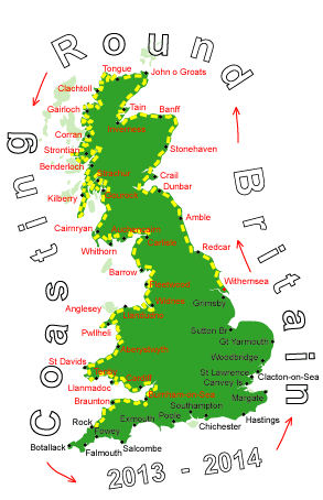
Log No 258. Thu 27th Feb 2014 - Boscastle to Port Isaac, 13 miles (3927 miles walked)

| The coastline from Boscastle |
There had been a shower of hailstones and waterproofs were the order of the day, it was mostly dry but showers were frequent though there was the occasional sunny interval. The wind was still strong and gusty.

| Rocky Valley |

| Tintagel Castle and Merlin's Cave |
The cave on Tintagel Head was called Merlin's cave and was a Silver-Lead mine at one time.
I stopped near the Castle for half my lunch.

| The wind blowing a waterfall back up over the cliff |

| Looking back over Trebarwith Strand |
At the top of the cliff I stopped to finish off my lunch and checking the map while I ate my sandwich I saw I still had 5 miles to do in less than 2 hours, so much for it being a stroll now. If I missed this bus I had a 2 hour wait.

| Looking back over Delabole Pt |
There was no time to eat a chocolate bar, I had to get up and go, running the downhill sections to make up for the slower ascents.
Pausing only for the one photo, I never stopped, occasional way markers gave the distance to Port Isaac and when I saw the "1 mile" marker with half an hour to go I knew I would make it and got there with 10 minutes to spare.
13 slower than expected miles.